
The Ultimate Glacier National Park Itinerary
- Zach Villaver
- 1 day ago
- 6 min read

Updated: 6 hours ago
Picture this: you round a corner on a road carved straight into a mountainside, a wall of granite on one side and a thousand-foot drop into a turquoise lake on the other. That's not a movie trailer. That's Going-to-the-Sun Road on a Tuesday.
Fifty-two miles of asphalt, blasted by hand into the spine of the Rocky Mountains, connecting the deep green shores of Lake McDonald to the wide-open prairie of the St. Mary Valley — this single road is the reason most people come to Glacier National Park in the first place. And unlike a lot of bucket-list drives, it hasn't been tamed into a forgettable commute. You still have to earn the best parts, one pullout at a time.

So if you're wondering where to actually stop, how long to budget, and which viewpoints are worth pulling over for, here's the stop-by-stop breakdown that separates a rushed drive-through from a trip you'll talk about for years.
Why Everyone's Obsessed With This Road
Going-to-the-Sun Road climbs over 3,000 feet in elevation, threads along the Garden Wall, and crosses the Continental Divide at Logan Pass — 6,646 feet above sea level — all without a guardrail long enough to make you feel truly safe (in the best way).

The best window to drive it is roughly July through September, once snowplows finish clearing the pass. A timed-entry vehicle reservation, booked separately through Recreation.gov, controls access to the west entrance section between 7 a.m. and 3 p.m. during peak season — so lock in your slot before you leave home.
Driven straight through with no stops, the full 50 miles takes about two hours. Budget four or more if you actually want to see it, since the real magic happens when you pull over and get out of the car. And if you want help choosing the best overlooks, trailheads, and photo stops instead of winging it, make sure to read the full Glacier National Park Travel Guide before you go — it’s your step-by-step companion to planning an unforgettable Going-to-the-Sun Road adventure.
Before You Start: Apgar Visitor Center
Just inside the West Entrance off Highway 2 in West Glacier, Apgar Visitor Center is where every drive should begin. The park entrance fee is $35 per vehicle for seven days (free with an America the Beautiful Pass), and inside you'll find restrooms, maps, and rangers with live updates on road conditions and recent bear activity.

Walk down to the shore of Lake McDonald before you get back in the car — glacier-fed, bone cold, and a shade of blue-green that doesn't look like it belongs in Montana.
Know before you go: the alpine section between Avalanche Creek and Rising Sun has size restrictions for vehicles over 21 feet long or 8 feet wide, so RV drivers should check conditions first. Speed limits run 45 mph along Lake McDonald and drop to 25 mph once you climb above Avalanche Creek.
The Stops Worth Pulling Over For
Lake McDonald
Ten miles long and nearly 500 feet deep, Lake McDonald was carved by a glacier that finished the job 10,000 years ago. Look at the lakebed pebbles — red, green, blue, and purple — iron-rich stone ground down and deposited right at the shoreline.
Sprague Creek Campground
Twenty-five sites tucked into hemlock and cedar on the lake's northeast shore, nine miles from the west entrance. It's a no-generator zone with some sites right on the water, though the length limit is a strict 21 feet — tents and vans only. Reservations go fast, so book early.

The Red "Jammer" Buses
Keep an eye out for the vintage red buses rolling along the road. When Going-to-the-Sun Road opened in 1933, many drivers were too intimidated by the cliffside drops to drive it themselves, so the park contracted the White Motor Company to build a fleet of open-air buses. Their drivers earned the nickname "Jammers" for the grinding sound of double-clutching on steep grades — a name that's stuck for over 90 years.
Johns Lake Loop
A short, two-mile loop through old-growth cedar that punches well above its weight. In that distance you'll pass Johns Lake, a quiet lily-pad pond; Sacred Dancing Cascade, a wide tiered waterfall considered a sacred site by the Kootenai people; and McDonald Falls, a 22-foot drop just before the creek reaches the lake.
Trail of the Cedars & Avalanche Lake
A 0.6-mile paved, fully accessible boardwalk loop through cedars and hemlocks, some approaching 500 years old. Midway, a footbridge crosses Avalanche Gorge — a slot canyon carved by glacial meltwater. For more, branch off onto the Avalanche Lake Trail: a 4.6-mile round trip gaining about 700 feet to a glacial cirque ringed by waterfalls fed by Sperry Glacier.
Red Rock Point
Easy to miss at road speed but worth every second — a pullout where McDonald Creek tumbles over tilted red and green argillite roughly 1.45 billion years old, still showing ripple marks from an ancient seafloor.

Logan Creek & Packer's Roost
Past Logan Creek, where the road begins its steepest climb, Packer's Roost marks the trailhead for Flattop Mountain — a serious 12-mile, 3,000-foot-gain backcountry route through active grizzly territory. This is also where mule trains still resupply the historic Granite Park Chalet today.
The Loop
The only switchback on the entire 50-mile road. Engineers originally planned 15 switchbacks up the west face of the Continental Divide; a single longer route with one sharp turn was chosen instead to protect the terrain. From here you're looking straight across the valley at Heavens Peak.
Bird Woman Falls & Paradise Meadows
Bird Woman Falls drops 960 feet from a hanging valley between Mount Oberlin and Mount Cannon. A little further on, Paradise Meadows is your first true alpine opening before Logan Pass — wildflowers carpeting the slopes from late June through August.
Triple Arches
A 65-foot, three-span concrete bridge designed on-site in 1927 after engineers scrapped the original retaining-wall plan. Look closely at the left arch — it's visibly off-angle from the other two and always has been. Nobody ever fixed it.

Oberlin Bend & Logan Pass
Oberlin Bend is the single best stretch of road for spotting mountain goats, sometimes walking right through the parking area. From Logan Pass itself, two trails define the park:
Highline Trail — an 11.6-mile point-to-point (with shuttle return) tracing the Garden Wall along the Continental Divide, with just 800 feet of elevation gain over 7.6 miles to Granite Park Chalet.
Hidden Lake Trail — a boardwalk climb behind the visitor center, 2.7 miles round trip to the overlook (5.4 miles to the lake itself), with mountain goats and bighorn sheep treating the path as their own.
Lunch Creek & Jackson Glacier Overlook
Lunch Creek exposes 1.5-billion-year-old Belt Supergroup rock layers, some holding fossilized stromatolites. A little further, Jackson Glacier Overlook is the only spot on the entire road where you can see a living glacier without leaving the parking area — though it's shrunk from 1,875 shared acres with Blackfoot Glacier in 1850 to under 200 acres today.
St. Mary Falls & Virginia Falls
A 1.7-mile round-trip descent through forest regrown since the 2015 Reynolds Creek Fire leads to St. Mary Falls, a three-tiered cascade over red Grinnell argillite. Push on another 0.6 miles for Virginia Falls, taller and wider, for a 3.7-mile round trip most people don't regret.
Baring Falls & Sun Point Nature Trail
Baring Falls is the shortest waterfall hike on the road — under half a mile. Just past it, Sun Point Nature Trail sits on the site of a 1915 Swiss-style chalet resort that closed once the road made horse-based tourism obsolete; the foundations are still visible in the grass.
Wild Goose Island Overlook
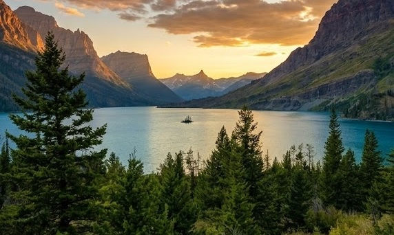
The most photographed scene in the park — a half-acre island rising 14 feet above St. Mary Lake, framed by the entire St. Mary Valley. It's a glacial remnant left when the ice retreated 10,000 years ago, best photographed at sunrise.
Rising Sun
Rising Sun Boat Dock has run scenic cruises on St. Mary Lake since 1938. Just past it, Rising Sun Motor Inn opened in 1940 and was the only park facility to stay open through World War II — still no TVs, air conditioning, or Wi-Fi in the rooms today.
What to Pack
Bear spray — rentable near the park entrances if you don't want to fly with it
Layers — mountain weather shifts fast, even in July
A refillable water bottle with a filter — glacial streams are tempting, but treat before you drink
Binoculars — for goat, sheep, and grizzly spotting from a safe distance
Broken-in hiking boots — this is not the trip to test new shoes
A paper map or downloaded offline map — cell service is nearly nonexistent past the entrances
Turn Going-to-the-Sun Road Into a Story, Not Just a Drive
Going-to-the-Sun Road is one of the most jaw-dropping drives in North America — but without context, it's just 50 miles of "wow, pretty" with no idea what you're actually looking at. A self-guided audio tour changes that completely: GPS-triggered stories play automatically as you drive, revealing the history, geology, and hidden details behind every hairpin turn and overlook — no cell signal required.
Download the Going-to-the-Sun Road Driving Tour now and let your car become your own private tour guide. Stories trigger automatically at 48+ stops along the route, so you'll never wonder "what am I even looking at?" again — just download it over Wi-Fi before you go, connect your phone to your car speakers, and let the road do the talking.


Comments